Zoan, Goshen, Rameses, and the Northern Yam Suf Hypothesis
Governing Thesis
If the Reed Sea of the Exodus is read as a reedy frontier-water system in the eastern Delta / Isthmus of Suez region, then the Israelites could plausibly have reached Yam Suf by moving through the Zoan–Goshen–Rameses corridor.
This thesis does not claim that the crossing site has been found. It does not pretend that ancient water can be fixed by a modern coordinate, nor that a biblical name must shrink to one point on a map. It does not discard the ancient Red Sea tradition. It does not require every biblical use of Yam Suf to name the same water. It makes a narrower claim, and therefore a stronger one: that the textual route, the Delta setting, and the reedy frontier waters cohere with a northern path from Rameses through the eastern corridor toward the border-lakes of Egypt.
The Eternal’s Own Park fixed the discipline by which this inquiry must proceed. Zoan must not be treated merely as a dot. A road must not be treated as ornament. The Delta must not be dried into a diagram. The map must be permitted to become wet again before it is asked to speak.
This present study follows that opened road eastward.
It asks whether the geography gathered around Zoan, Goshen, Rameses, and Avaris may also supply the most coherent approach to Yam Suf, when Yam Suf is read not only as the distant open sea, but as the reedy waters at the edge of Pharaoh’s world.
Prayer Before the Route
Lord God Almighty,
Eternal Father, Maker of land and sea,
You who led Your people out by a mighty hand,
You who divided waters and opened roads,
You who remember places as well as promises,
guide this search.
Let no novelty seduce it.
Let no inherited phrase harden into blindness.
Let no beautiful possibility be mistaken for proof.
Let no fear of correction silence the question.
Teach us to distinguish road from destination,
field from city,
reeds from sea,
water from modern map,
possibility from discovery.
Let the text rule over imagination.
Let geography serve the text without mastering it.
Let evidence speak in its proper measure.
Let wonder be disciplined until it becomes trustworthy.
If this path is fruitful, open it.
If it is flawed, correct it.
If it is premature, restrain it.
If it is appointed for edification, make it clear.
May the work produce humility, clarity, courage, and truth.
May it glorify not the searcher, but You, the Eternal, whose acts sanctify road, field, water, wilderness, and word.
Amen.
Preface: The Road and the Water
This work began downstream from another search.
The Eternal’s Own Park opened the northeastern Delta by refusing to let Zoan remain a mere dot, refusing to let road-language remain decorative, and refusing to let the modern dry map silence the ancient wet one. That prior inquiry did not close the map. It opened it. The road ran northeast through the Delta. Its name was Zoan.
This inquiry turns east.
Its question is not whether Zoan is the crossing. It is not. Its question is whether the same Delta theater that gathers Zoan, Goshen, Rameses, and Avaris also gives a plausible road to the Reeds.
The question must be asked slowly. Ancient Egypt’s eastern edge was not a blank strip between river and desert. It was branch, canal, basin, marsh, lake, pasture, road, fort, harbor, shrine, and gate. It was a managed frontier. It was where Egypt faced Asia. It was where imperial order thinned into wilderness.
That is the setting in which the Exodus begins to move.
Rameses gives the point of departure. Goshen gives the covenantal habitation. Zoan gives the regional witness. Wadi Tumilat gives the eastern opening. The reedy lakes of the Isthmus give the candidate waters.
The thesis does not need to force certainty. It needs only to ask whether these names belong to the same world.
They appear to do so.
The road has opened. The water waits at the edge.
Discernment at the Water’s Edge
The Holy Spirit does not require the scholar to exaggerate geography in order to honor deliverance; He requires the scholar to love truth enough to let the waters remain where the evidence permits them.
The search begins, therefore, under restraint. We do not seek a spectacle. We seek a road. We do not need to make the marsh grander than it was. We do not need to make the sea smaller than Scripture allows. We do not need to flatten an ancient name into one modern shoreline. We need to ask what the text, the route, and the land can bear together.
This inquiry must resist five temptations. The first is reduction: to make Yam Suf mean only one thing in every text. The second is reaction: to treat “Reed Sea” as if it were automatically wiser than “Red Sea.” The third is romance: to mistake a beautiful northern route for a proven one. The fourth is timidity: to refuse a plausible question because it is not yet a conclusion. The fifth is conquest: to treat the map as mastered because the argument has become coherent.
The virtues required are equal in severity: patience, sobriety, courage, reverence, and obedience to measure. Patience lets a corridor remain a corridor. Sobriety keeps a lake from becoming an idol. Courage follows a difficult route without pretending it is uncontested. Reverence remembers that the Eternal’s deliverance is not diminished by geography. Obedience to measure says only what the evidence permits and asks all that the evidence invites.
The rule of the search is therefore simple:
Let the road remain a road. Let the water remain water. Let the name remain under discipline until text, map, and memory answer one another.
Wonder opens the route. Evidence marks the banks. Wisdom decides the crossing.
Part I
The Opened Corridor
1. The Corridor Already Opened
The earlier Zoan inquiry recovered a truth easily lost in modern reading: a road in Scripture is not always a line. It can be an approach, a remembered passage, a district of movement, a zone where water, settlement, power, and memory gather.
That recovery matters for Yam Suf.
Moffatt’s Genesis 13:10 does not merely place Egypt beside Edenic abundance. It places Egypt on a way: “the land of Egypt on the way to Zoan.” The phrase has direction in it. The text is not content with fertility in the abstract. It gives motion. It gives approach. It gives a road through a wet world.
The present study does not reargue every plank of that earlier work. It receives the road as opened and asks a second question: once the corridor is granted, where does it lead when Israel begins to move?
If “on the way to Zoan” points toward a northeastern Delta world of branch-rivers, canals, sacred enclosures, royal memory, and covenantal tension, then the first movement of the Exodus may also belong to that same world.
Not because Zoan is Yam Suf.
Not because Tanis is the crossing.
Not because every name must be forced into one place.
But because biblical geography often remembers theaters, not merely coordinates.
The way to Zoan may illuminate the way to the Reeds.
2. Zoan as Witness, Not Crossing Site
Zoan is not mist.
It is commonly identified with Tanis in the northeastern Nile Delta. It stands as one of the great names by which Egypt’s Delta memory enters Scripture. It belongs to the world of ports, approaches, royal power, and Asiatic-facing geography.
But the phrase that matters most here is not merely Zoan. It is the field of Zoan.
The field prevents the city from swallowing the region. It allows Zoan to function not only as an urban point, but as a regional register of memory. Psalm 78 remembers divine wonders in Egypt under the sign of Zoan. The psalm does not place the sea crossing at Tanis. It does something more subtle and more useful: it lets the Exodus memory sound in a Zoan-associated Delta key.
This must be kept severe.
Zoan is not the sea.
Zoan is not the crossing.
Zoan is not the answer to every geographical question.
Zoan is the witness.
It names a Delta theater in which Egyptian power, Israelite affliction, divine judgment, and sacred geography converge. That witness does not solve Yam Suf. It prepares the field in which the question can be asked.
If the wonders of Egypt can be remembered in the field of Zoan, then the movement from Israel’s settlement-zone toward Yam Suf need not be imagined as a disconnected leap from inland Egypt to an unrelated sea. It may be the eastern unfolding of the same Delta world.
3. Goshen: The Covenantal Enclave
Goshen must not be seized too quickly.
It should not be collapsed into the field of Zoan. The earlier Zoan study was right to refuse that shortcut. The strength of the argument lies not in identity, but in convergence. Goshen and Zoan need not be the same place in order to belong to the same sacred-geographical theater.
Goshen is not merely pasture.
It is settlement under promise.
It is nearness and separation.
It is Israel inside Egypt and not finally Egypt’s possession.
In the plague narratives, Goshen becomes a land of divine distinction. The Eternal marks a difference between His people and Pharaoh’s people. Geography becomes witness. Land is not neutral. It is acted upon, spared, separated, made to testify.
That is why Goshen matters for the road to the Reeds. If Israel dwells in the eastern Delta, and if that eastern Delta opens toward Wadi Tumilat and the Suez frontier, then the Exodus does not begin in abstraction. It begins in a covenantal enclave near Egypt’s threshold.
Goshen gives the human-covenantal side of the theater.
Zoan gives the regional witness.
Rameses gives the departure.
Wadi Tumilat gives the road.
The reedy waters give the barrier.
Part II
Road, Threshold, and Frontier Waters
4. Rameses, Avaris, and the Threshold
The biblical itinerary begins with Rameses.
That beginning is not incidental.
Rameses belongs to the eastern Delta world of Pi-Ramesses, Qantir, Avaris, and Tell el-Dabʿa. Avaris is identified in modern archaeological work as the Hyksos capital and as the southern part of Pi-Ramesse, the Delta residence of Ramesses II and his successors. It stood in the eastern Delta, in a landscape of Nile branches, routes, trade, frontier control, and access toward the Horus Road.
That setting is crucial.
Rameses/Avaris is not merely a name in an itinerary.
It is a threshold.
It is royal, watery, strategic, Asiatic-facing, road-connected, and frontier-conscious. It belongs to the kind of geography in which departure, pursuit, and entrapment make sense.
The deeper Delta pattern already established by the Zoan study now becomes useful again: Avaris, Pi-Ramesses, and Tanis/Zoan are not loose names scattered across an unrelated map. They belong to a moving Delta geography. Branches shift. Capitals migrate. Monuments are transferred. Sacred-royal memory is reconstituted around water.
Israel does not begin in a mythic nowhere.
Israel begins at Egypt’s threshold.
The road from Rameses is already a road toward the edge.
5. Wadi Tumilat: The Eastern Opening
Wadi Tumilat is the hinge.
It is the corridor by which the eastern Delta opens toward the Isthmus of Suez. It is the kind of place a modern map can understate: a fertile passage, a frontier approach, a corridor of water, herds, traffic, control, and movement.
A northern Reed Sea reconstruction commonly places the early itinerary along this route. Rameses gives the departure. Succoth marks the first named stage. Etham stands near the eastern end of the corridor, close to the border-lake world.
This is not proof.
But it is coherence.
It explains why Israel can be leaving Egypt and still remain within Pharaoh’s reach. It explains why pursuit is possible. It explains why entrapment is plausible. It explains why water, wilderness, and imperial control belong to the same scene.
The people are not yet in the deep wilderness.
They are at the frontier.
And the frontier is where Egypt begins to thin.
6. The Frontier Where Egypt Thins
The frontier is not emptiness.
It is pressure.
It is the place where road becomes risk, where settlement gives way to watchfulness, where managed water becomes barrier, where Pharaoh’s order meets the wilderness it cannot finally command.
That is the proper dramatic setting for Exodus 14. Israel has moved, but not escaped. Pharaoh has lost his slaves, but not yet his reach. The people stand between road and water, between empire and wilderness, between the old master behind them and the impossible passage ahead.
Such a setting does not weaken the miracle.
It gives it terrain.
The Eternal does not deliver Israel from an idea. He delivers Israel through a place. The road matters. The water matters. The edge matters.
The frontier is where the map becomes theological.
Part III
The Name and the Waters
7. Yam Suf and the Discipline of Translation
The name Yam Suf must be handled with severity.
A beautiful translation is not automatically true.
An ancient tradition is not automatically false.
The traditional rendering “Red Sea” is old and weighty. It stands behind Greek, Latin, Jewish, and Christian reception. It should not be mocked as a late English confusion. A thesis that begins with a false dismissal of tradition has already injured itself.
Yet the Hebrew also presses. Yam is sea, or a large body of water. Suf belongs to the world of reeds, rushes, and water-plants. Moses’ basket rests among the suph by the Nile. The word carries marsh and plant-life in its sound.
Therefore the question is not trivial.
Nor is it solved by etymology alone.
The responsible question is this: could Yam Suf, in the Exodus crossing context, refer to a substantial reedy water-body or lake-system on Egypt’s eastern frontier?
The northern hypothesis answers: yes, plausibly.
But it must say so carefully.
Yam Suf should not be reduced to a swamp.
It should not be reduced to a few reeds.
It should not be reduced to a modern canal-zone.
It should not be severed from the ancient Red Sea tradition.
The strongest formulation is narrower:
Yam Suf near the Exodus route may designate a significant water-body within the larger reedy frontier system east of the Delta.
That gives the reeds their force without making the reeds do all the work.
8. The Isthmus of Suez and the Reedy Lakes
The northern Reed Sea reading looks toward the Isthmus of Suez: the land between Mediterranean coast, eastern Delta, Sinai approach, and Gulf of Suez.
This region was not the modern canal-map alone. It included marshy lakes, shifting water-levels, border waters, channels, and reedy margins. Ballah Lake, Lake Timsah, the Great Bitter Lake, and the Little Bitter Lake belong to the candidate world.
The point is not that every candidate is equal.
Ballah Lakes may carry the strongest northern claim in this reconstruction.
Lake Timsah matters because Wadi Tumilat approaches it.
The Bitter Lakes matter as part of the same isthmus system.
The Gulf of Suez matters because the broader Red Sea tradition cannot be dismissed.
But the thesis does not require one candidate to be crowned too soon. The thesis requires only that the road from Rameses through Wadi Tumilat naturally approaches a reedy frontier-water system.
That requirement is met.
The route and the name begin to answer one another.
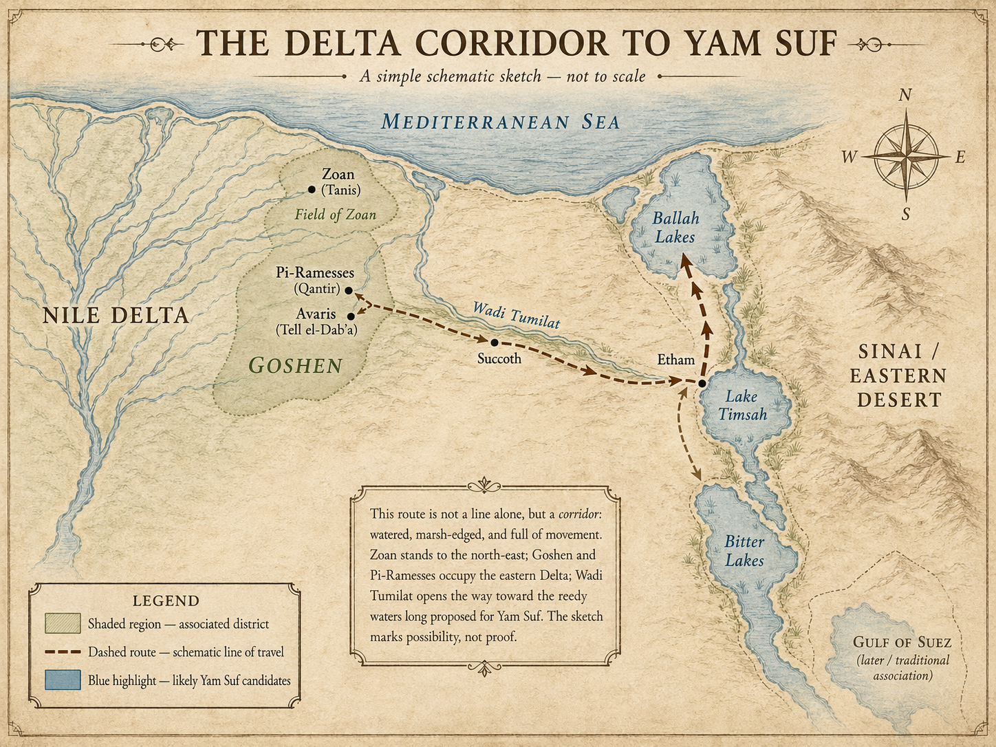
9. The Route Reconstructed
The route may now be stated with disciplined simplicity.
Zoan / Tanis stands to the north as the great Delta witness, associated biblically with the field of Zoan.
Goshen occupies the eastern Delta settlement-zone, the covenantal enclave where Israel dwells inside Egypt yet under divine distinction.
Rameses / Pi-Ramesses gives the departure point: royal, watery, strategic, and close to Avaris.
Avaris / Tell el-Dabʿa gives the older threshold-world: port, route-node, Asiatic-facing gate, and frontier center.
Wadi Tumilat opens the way eastward.
Succoth marks the first named stage.
Etham stands near the eastern end of the corridor, at or near the edge of the wilderness and border-lake world.
Yam Suf, on the northern reading, lies among the reedy frontier waters of the Isthmus of Suez: especially the Ballah Lake / Lake Timsah / Bitter Lakes system.
Thus the schematic movement is this:
Rameses → Succoth → Etham → turning movement toward the sea → encampment before the water-barrier → crossing.
This is not yet proof.
But it is intelligible.
It keeps Israel within reachable distance of the eastern Delta. It accounts for Pharaoh’s pursuit. It allows the people to be trapped between water, wilderness, and Egyptian force. It gives Yam Suf a reedy hydrological setting. It lets the field of Zoan memory remain part of the larger Delta theater without forcing Tanis itself into the crossing event.
The road is not a line.
It is a corridor under pressure.
Part IV
Evidence Under Discipline
10. The Objections That Must Remain
A responsible thesis must preserve its own difficulties.
First: Yam Suf is not used in only one biblical setting.
Some biblical uses of Yam Suf appear to refer to waters beyond the northeastern Delta. The term cannot be reduced simplistically to one northern lake in every occurrence. Context must govern.
Second: the Red Sea tradition is ancient.
The Septuagint, Josephus, the Vulgate, and later Jewish and Christian traditions matter. “Red Sea” is not a disposable mistake. The northern Reed Sea thesis is weakened if it begins by scorning the tradition it must interpret.
Third: reeds alone do not make a sea.
A reedy marsh-region is not automatically the crossing site. The strongest argument requires a substantial water-body within the reedy frontier system. This is why Ballah Lake, Lake Timsah, and the Bitter Lakes matter more than reeds in the abstract.
Fourth: Zoan and Goshen should not be collapsed.
The established Zoan study preserved the distinction between field of Zoan and Goshen. That discipline must remain. The argument is not identity. It is convergence.
Fifth: the route is plausible, not proven.
A plausible route is not a discovered crossing site.
The map has opened.
It has not surrendered.
11. The Evidence Ladder
Not all evidence stands at the same height. The road must be ranked before it can be followed responsibly.
Rung I: Direct Geographic Anchors
Zoan is commonly identified with Tanis in the northeastern Nile Delta. Avaris / Tell el-Dabʿa lies in the eastern Delta and is identified with the Hyksos capital and the southern part of Pi-Ramesse / Qantir. These are the strongest coordinates.
Rung II: Textual Route Markers
The Exodus itinerary begins at Rameses and moves to Succoth and Etham. A northern reconstruction places those early movements along or near Wadi Tumilat, toward Egypt’s eastern border and the border-lake region. These markers give sequence.
Rung III: Hydrological Context
The Isthmus of Suez included marshy lakes in antiquity: Ballah Lake, Lake Timsah, and the Bitter Lakes. The ancient landscape differed from the modern one. This gives the route water.
Rung IV: Linguistic and Toponymic Evidence
The Hebrew suph is associated with reeds or rushes, and Egyptian reed terminology has been connected by some scholars with the eastern frontier lake region. This gives the waters a name.
Rung V: Regional Biblical Memory
Psalm 78’s field of Zoan and the established Zoan corridor suggest that divine action in Egypt could be remembered under a Zoan-associated Delta geography. This gives the route a biblical theater.
Rung VI: Theological-Literary Coherence
The route places Israel at the frontier of Egypt: no longer settled, not yet free; no longer at rest, not yet in wilderness; still reachable by Pharaoh, yet already under the guidance of the Eternal.
This is not proof in the archaeological sense.
It is coherence in the textual-theological sense.
12. Final Rule of the Route
The work ends not with possession, but with measure.
The crossing site has not been found. Ballah Lake has not been proven. Lake Timsah has not been crowned. The Bitter Lakes have not been excluded. The Gulf of Suez tradition has not been silenced. Yet the road has become real enough to follow: Zoan, Goshen, Rameses, Avaris, Wadi Tumilat, border-lakes, reeds, sea, wilderness, and Scripture.
That is no small thing.
The final rule is therefore the first rule restored:
We do not need to exaggerate evidence to glorify God. We glorify Him by telling the truth.
If this path is fruitful, let it open. If flawed, let it be corrected. If premature, let it be restrained. If appointed for edification, let it be made clear.
Wonder opens the route. Evidence marks the banks. Wisdom decides the crossing.
Appendix A
Research Program and Field Questions
The research program proceeds in five stages: receive the Zoan corridor; locate the covenantal settlement-zone; reconstruct the route from Rameses through Wadi Tumilat; recover the reedy frontier waters; and ask whether Yam Suf in the Exodus crossing context is best understood as a substantial water-body within that eastern Delta / Isthmus of Suez system.
The evidence classes are textual, toponymic, hydrological, philological, and theological-literary. Textual evidence includes the Exodus itinerary, Psalm 78’s field of Zoan, and the broader biblical uses of Yam Suf. Toponymic evidence includes Zoan, Tanis, Rameses, Avaris, Succoth, Etham, and the names attached to the eastern frontier waters. Hydrological evidence includes Nile branches, Wadi Tumilat, border lakes, marshes, reeds, canals, and the changed landscape of the Isthmus. Philological evidence includes the relation between yam, suph, reeds, rushes, and the ancient Red Sea tradition. Theological-literary evidence includes the pattern by which Scripture makes place bear meaning: Eden, Goshen, Sinai, wilderness, river, sea, mountain, and road.
The field questions remain severe enough to discipline the imagination:
Can Zoan’s field function as a regional Exodus memory without making Tanis the crossing site?
How close, geographically and conceptually, should Goshen be placed to the field of Zoan?
Does Rameses / Pi-Ramesses provide the most plausible departure-world for the itinerary?
Does Wadi Tumilat best explain the movement from Rameses to Succoth and Etham?
Which candidate waters best satisfy the combined demands of route, reeds, substantial water, frontier control, and narrative entrapment?
Can Yam Suf be read as a reedy frontier-water designation in Exodus without erasing its wider biblical and traditional Red Sea associations?
What evidence would move the thesis from plausible corridor to preferred reconstruction?
What evidence would falsify or weaken it?
The work must remain answerable to these questions.
Appendix B. Bibliographic Orientation and Source Markers
Biblical Texts
Genesis 13:10; Exodus 1:11; Exodus 2:3–5; Exodus 12:37; Exodus 13:17–20; Exodus 14:1–2; Exodus 15; Numbers 33; Psalm 78; Isaiah 19; 1 Kings 9:26.
Translation and Textual Orientation
Moffatt, James. The Bible: A New Translation. Important for the translation path that renders Yam Suf as “Reed Sea” and for the Zoan-related reading that prompted the prior inquiry.
Foundational Prior Inquiry
Fahy, Tom. The Eternal’s Own Park. Provides the governing discipline for the present essay: Zoan must be read as city, field, corridor, and remembered Delta theater; the road is not decorative; and the map must become wet again before it can speak.
Zoan / Tanis
Britannica. “Tanis.” Useful for identifying Tanis with Zoan and locating it in the Nile Delta near the Asiatic seaboard.
Jewish Encyclopedia. “Zoan.” Useful for biblical references to Zoan and the interpretive question of the “field of Zoan.”
Avaris, Pi-Ramesses, and the Eastern Delta
Austrian Archaeological Institute. “Tell el-Dabʿa / Avaris.” Useful for Avaris in the eastern Delta, its identification with the Hyksos capital, its relation to Pi-Ramesse / Qantir, its port function, and its strategic position near the Horus Road.
Bietak, Manfred. Avaris and Pi-Ramesse: Archaeological Exploration in the Eastern Nile Delta. Important background for the Avaris / Pi-Ramesses complex, eastern Delta archaeology, and the movement of sacred-royal geography through time.
Bietak, Manfred. Avaris, the Capital of the Hyksos: Recent Excavations at Tell el-Dabʿa. Important for the deeper archaeological history of Avaris and its Asiatic connections.
Exodus Route and Northern Reed Sea Studies
Byers, Gary. “New Evidence from Egypt on the Location of the Exodus Sea Crossing: Part I.” Associates for Biblical Research. Useful for the Isthmus of Suez, Ballah Lake, Lake Timsah, Bitter Lakes, marshy freshwater systems, and the claim that ancient hydrology differed substantially from the modern map.
Byers, Gary. “New Evidence from Egypt on Location of Exodus Sea Crossing: Part II.” Associates for Biblical Research. Useful for the proposed Rameses–Succoth–Etham sequence through Wadi Tumilat and toward the eastern border lake region.
Hoffmeier, James K. Israel in Egypt: The Evidence for the Authenticity of the Exodus Tradition. Oxford University Press, 1996. Important for eastern Delta geography, Egyptian background, and the historical plausibility of certain Exodus-route features.
Hoffmeier, James K. Ancient Israel in Sinai: The Evidence for the Authenticity of the Wilderness Tradition. Oxford University Press, 2005. Important for the wilderness tradition, the route problem, and the Yam Suf discussion.
Kitchen, K. A. On the Reliability of the Old Testament. Eerdmans, 2003. Important for Old Testament historical geography, conservative reconstruction, and discussion of the route and terminology.
Yam Suf Translation and Interpretation
Zivotofsky, Ari Z. “What’s the Truth about . . . the Translation of Yam Suf?” Jewish Action. Important for preserving the weight of the ancient Red Sea tradition and correcting the claim that “Red Sea” arose from a late English confusion.
Bratcher, Dennis. “The Yam Suph: ‘Red Sea’ or ‘Sea of Reeds’?” CRI/Voice Institute. Useful as a general orientation to the Hebrew terms yam and suph, the translation issue, and the route debate.
Ben-Gad HaCohen, David. “The Yam Suph in the Transjordan?” TheTorah.com. Useful for the broader biblical usage of Yam Suf and for the caution that the term cannot be reduced simplistically to one location in every biblical context.